
Tungog Lake Kopel, Kinabatangan River, Sabah
The Lower Kinabatangan Segama Wetlands and Forever Sabah
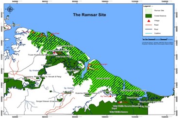
Wetlands and coastal ecosystems are highly productive areas which many communities rely on for sustenance, shelter, and income in Sabah, Malaysian Borneo. The Lower Kinabatangan Segama Wetlands site includes 78,803 hectares of contiguous mangrove, lowland riparian & peat swamp forests with a designated protected status as Malaysia’s largest Ramsar site. Communities located within and around the Lower Kinabatangan and Segama Wetlands (LKSW) are assisted by Forever Sabah, a civil social entity or movement that cooperates with indigenous communities to connect them with the Sabah Forestry Department and other local and international organizations. They aim to facilitate mutually-inclusive decision-making and building capacity and trust with community members. The LKSW community engagement programme was formally launched in 2015 and is funded by the Global Environment Facility’s Small Grants Programme and IUCN.
Team Generation Restoration worked with Forever Sabah and Kampong Dagat, a member community of the LKSW programme. We are committed to exploring sustainable and equitable solutions to pertinent environmental problems, and to helping this community develop and implement restoration plans and monitoring programmes for riparian and mangrove ecosystems that the community relies upon. While fisheries are their traditional source of income, upstream deforestation along the Tabin River and water quality degradation has forced the community to uptake alternative sources of revenue through ecotourism and swiftlet nest farming. Kampong Dagat has also initiated the Community Orangutan Ranger Team (CORT) to track and monitor populations of Northeastern Bornean Orangutans near Kampung Dagat with the aim of securing key habitats with the Sabah Forestry Department and minimizing human-wildlife conflict.
Batu Puteh Community on the Kinabatangan River by KOPEL Bhd.
Threatened by land conversion of riparian and lowland dipterocarp forests into oil palm plantations, many indigenous communities along the Lower Kinabatangan like the Sukang ethnic people of Kampung Batu Puteh faced a troubling dilemma with few options. Fortunately villages around Batu Puteh, the limestone karsts that gave the locality its name resulted in the protection of the Lower Kinabatangan within the Pin-Supu Forest Reserve, where valuable Edible-nest Swiftlets reside. From there, community champions from villages within the Forest Reserve pioneered ecotourism in a venture known previously as MESCOT, paving the way for future restoration projects.
KOPEL evolved as a conglomeration of multiple village homestays and ecotourism ventures of four villages: Kampong Batu Puteh, Kampong Menggaris, Kampong Perpaduan, and Kampong Singgah Mata. As a community cooperative, KOPEL offers a shared pool of resources, core restoration and sustainability services and research products for organizations like the Sabah Forestry Department, and a flagship ecotourism project: Tunggog Eco Camp.
With a long history of setting up, monitoring and troubleshooting riparian restoration sites around Kampung Batu Puteh, Dr Gretchen Coffman has paved the way for Team Generation Restoration to collaborate with the community champions and members of Kampong Batu Puteh and KOPEL Bhd.
Links to our collaborator’s and partner’s website
- Forever Sabah: https://www.foreversabah.org/
- KOPEL: https://www.kopelkinabatangan.com/
- TRACC: https://tracc.org/
- Bornean Sun Bear Conservation Center: https://www.bsbcc.org.my/index.html
- Tanjung Aru Marine Ecosystems Centre (TAME): https://www.facebook.com/TAMECenter/